Exploring the Final Frontier from Orbit

A couple of weeks back, we set forth in our sparkly new FTL survey ship to explore the 15,000 star systems within 100 light years of Earth. We hopped around a particular system to track down any planets it might have, and now we’re going to take a closer look at them. While it would be fun to zap down to the surface to get hands-on information, our mission really is survey. Let’s find the interesting places and let some other poor schmuck get fitted for a red shirt.

So what can we do from orbit?

In a lot of ways, this is a question for the CIA, or more accurately the National Reconnaissance Office (NRO), the agency in charge of the various US spy satellites. Most of us think of spy satellites as peeking in on missile complexes or uranium enrichment plants, but at a lower resolution, they are quite useful for map-making.

And that gets right to the heart of the matter: resolution vs. coverage area. The optical sensor in your orbital platform is of some fixed size. Maybe it’s ten centimeters or a full meter, but the key is that it’s a fixed number of pixels across, perhaps a hundred thousand. If your optical lenses project an image that represents a square kilometer on the ground, your resolution would be one hundred thousandth of a kilometer, i.e. a centimeter.

While centimeter resolution might thrill the NRO, it’s wasted on us for survey purposes, and the Earth would require at least 500 million of those snapshots. If we had that large of a sensor, we would be much better off taking snapshots of 100km by 100km and getting 1 meter resolution.

You can play around with this a little by taking pictures of things not directly beneath you but scanning east to west and patching them together, but doing it quickly (that is, at orbital speeds) could get quite complicated. I don’t know if our current spy satellites can manage that kind of east-west scanning, or if they simply have to pick their targets more carefully.

In addition to visible-light photography, we can take photographs at varying resolutions in the infrared and ultraviolet. Add in a RADAR transmitter, and we can do terrain height mapping as we fly over.
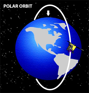
But how long does this take? Let’s assume a planet the size of the Earth. We do our observations from a polar orbit, taking 100km-wide swaths of photographs as we go. We’ll get lots of overlap near the poles, but we have to make enough passes to cover the entire equator in 100km chunks. At 40,000km around, that’s 400 passes. Orbit times depend on the mass of the planet and the height of the orbit, and on earth we see orbits range from 92 minutes (on the International Space Station) to 27 days (the moon).

But the Earth spins, and since that’s helpful, let’s hope our new planet does too. After 92 minutes, the equatorial land we pass over on the day-side is 2500km from the last picture we took. It would be nicer if it had only moved 100km, but we can work with that. If we choose our orbital altitude correctly, we can get our orbital period to line up so that we’re always hitting some multiple of 100km from the last pass, and with the right rhythm, we’ll keep hitting fresh bits of the equator. It’s one of those prime factor things, cycling over 400 swaths by 3’s (or 7’s, 11’s, 13’s, etc.) will keep hitting new swaths.

We may as well photograph things on the night side as well to capture any surprises like city lights, but we’ll mostly want the daylight side. So that’s 400 orbits of 90 minutes or more, which will take at least 25 days. It would take longer if we want higher resolution, or be done quicker if we settle for lower resolution. Notably, that centimeter resolution could take years, while backing off to 10m resolution could get the job done in a few days. Oh, and then there might be weather getting in your way.

See what I mean about the quandary of coverage vs. resolution? When flying over some of the overlapped areas away from the equator, you can squeeze in some zoomed shots of the more interesting bits, but your overall schedule is going to push your towards the lower resolution. With 15,000 star systems to get to, it’s going to be a hard argument to push for something greater than 10m resolution.

But what can we do to fit more into our schedule? I’ll be talking about that next week when I go after some of the logistics to make this survey project more feasible. Or maybe I’ll just see how mammoth it really is. Either way, I’m still wallowing in wish fulfillment, eager to don my Survey uniform.

Exploring the Final Frontier

You’ve just been given the keys to your own FTL explorer ship… what do you do? This is a thought experiment that borders on wish fulfillment, but the kid in me thinks that’s the best kind. For all the flaws of the Star Trek prequel series Enterprise, it at least had some fun playing around with the “explore new worlds” part of the mission, and I really enjoyed those episodes.

So let’s play around with it some ourselves. Assume we’ve reached the level of space technology where we’ve set up a few permanent outposts throughout the solar system, and we’re able to build some reasonable spacecraft for scooting around the neighborhood. Then suddenly, FTL goes from a surprising theoretical possibility to an even more surprising engineering reality.

The NX-01 Enterprise rolls off the line, then the NX-02, and so on. They go off and take snapshots on Rigel-4 and draw lots to see who gets the next red shirt.

Meanwhile, you get a much more boring assignment on the exciting starship Survey-4. While those dashing captains check out the Top 40, you get to fill in the gaps, and there are some pretty big gaps. Within 100 light years, there are about 15,000 stars. Within 500 light years, there are almost two million. So if we’re going to be jetting around at warp 7, then there’s a lot of stuff between here and Rigel. (Approximately 850 light years, in fact.)

So where do you even start on an assignment like this? Let’s assume we got called in early on the project, so we can help lay out the scope of the mission. That is, what are we looking for? What do we need to find it? Where are we going to look? And just how long is this going to take?

We’re probably looking for life or at least places we could live, and from that we can narrow the scope a little bit, since not all stars are likely to support life as we know it. However, we’re probably also looking for useful resources, points of scientific interest, and staging points for further exploration. As such, we probably want to at least stop off at each star and give a quick look around.

What do we want from that quick look around? Personally, I’d want to know if there were any planets, and if so, how many? And if any of them seemed interesting, i.e. in the habitable zone, have big moons, or simply look pretty, I’d want an orbital survey on them.

Finding the inner planets will be easy enough by their reflected light. We found most of the ones in our solar system without even the aid of a telescope, simply because of the motion of planets against the background of otherwise static stars. The actual motion of the planets may not help us here, since waiting for Uranus or Neptune to move an appreciable fraction of their orbits can take a while.

However, the apparent motion of the planets will help us a lot. When an Earth-bound observer sees Saturn move against the stars, some of that motion is truly the motion of Saturn, but some of it is also the motion of Earth. As the Earth bounces back and forth from one side of the sun to the other, the viewing angle to Saturn swivels back and forth. In many cases, it appears as though it has reversed its orbital course, but it’s really just our own movement around the sun causing that motion. (This is what people mean when they say a planet is “in retrograde”, just that the relative motion of Earth and the planet makes it look like it’s going backwards.)

Well, in our nifty FTL survey ship, we should be able to bounce around in much less than the year Earth takes. The idea is to take a high resolution picture of the stellar system with our camera pointed towards a fixed location, like good old Sol, and when I say high-resolution, I’m thinking about stitching together a few thousand telescopic snapshots. Then move over a billion kilometers to the left, aim this camera array towards Sol, and take another picture. The position of the stars should stay more or less the same. Anything that appears, disappears, or moves from one picture to the next is probably local. (Or maybe some distant pulsar is just dicking with you.) If you do this from two or three directions, you should get a pretty good map of the inner planets.

It might not get you some of the outer planets. Neptune and Pluto were not originally discovered by telescope but by their gravitational interactions with Uranus. However, assuming better telescopes, no atmospheric interference, and better image processing than the eyes of early 20th century astronomers, we would probably find anything down to Pluto’s brightness. Whether or not we’d see something like Eris out in the Kuiper belt is more speculation than I’m willing to make right now.

So, what do we do with these planets once we’ve found them? As much as I’d love to send down some red shirts (and maybe even some people in them) to explore, an initial survey such as this should probably limit itself to space-based observations.

Telescopic observations can tell us a fair amount from a distance, but mostly that information can be used to rule out some planets from a more detailed survey. Spectrum absorption lines can tell us a lot about atmospheric makeup, and we can also measure the temperature to some degree. If it’s 200 degrees (or -200), then we’re probably not going to find life or suitable colony locations on it. I think we can also get a moderate idea of the atmospheric depth via telescope, since we knew of Mars’ minimal atmosphere years before we sent probes. (Though I confess, the science for extracting that info is beyond me.)

But if the atmosphere and temperature look appealing, it might be time for a much closer look. Just how much of a look can we actually take from space? I’ll take a stab at that next week.

Anything else you’d want from your initial system survey?